By Victor Mastone, Massachusetts Board of Underwater Archaeological Resources
Shipwrecks are often tales of tragedy, mystery, drama, and treasure. The poster for this year's Massachusetts Archaeology Month features an unknown shipwreck on Coffins Beach in Gloucester. While its identity is a mystery, the shipwreck provides an important window into our maritime past.
The local, regional, and national importance of the maritime legacy of Massachusetts is readily evident. Massachusetts has long been a major center of maritime commerce and naval activity in North America. The ports of Massachusetts, such as Boston, Plymouth, Salem, Gloucester, Provincetown, New Bedford, Nantucket, and Newburyport, can be best described as the historic maritime gateway to the commerce of North America. These ports and numerous smaller ports provided the extensive maritime infrastructure for vital commercial and naval activities. More than 2,000 maritime historical sites have been identified on land (terrestrial) around Massachusetts Bay alone. It has been reliably estimated that over 3,500 shipwrecks are located in Massachusetts' waters.
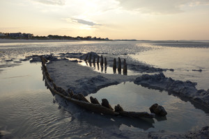
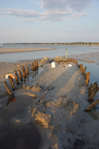
In late spring 2014 at Coffin's Beach in Gloucester, seasonally shifting channels and sand bars began to offer up a glimpse of Massachusetts's maritime past. A small shipwreck began emerging from sands at the toe of Coffins Beach. The site which is normally immersed in the high energy (surf) zone, lying seaward of the beach, was now partially uncovered at low tide. A curious local resident contacted the Massachusetts Board of Underwater Archaeological Resources to see if we could identify this shipwreck.
Archival research identified upwards of 40 shipwrecks, from 1635 to 1936, in the general vicinity of this wreck. These included shallops, schooners, sloops, ketches, and various fishing boats. In the early 20th century, there was an early gillnetter lost fairly close to the wreck site. The visible marine growth on the exposed wreck and testimony of local residents suggested that this vessel had only emerged recently and had likely been buried for at least a half century. Any vessel identity seemed very speculative.
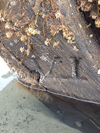
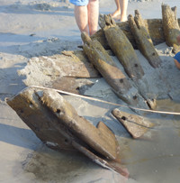
The preliminary field investigation took place over several visits in the summer and early fall during periods of extreme low tides, and before the sands of Coffins Beach reclaimed the wreck once again. A metal detector survey was conducted along the inside and outside the hull, at each futtocks and the stem. The occasional hits turned out to be fragments of broken/degraded wire lobster traps that had collected around the wreck. No metal ship fittings were observed. The visible end of the vessel was uncovered to reveal that the apparent stem/cutwater is one solid and massive piece of oak. It was rabbeted and matched the planking. Draft marks for depicting the waterline were evident on the stern. Seeing both the "VI" and "V", meaning 6 and 5 feet respectively, we would conclude there is more vessel remaining deeply buried in the sand. We traced out the sides of the hull toward opposite end. Despite extensive probing, the stern could not be positively located. However, buried planking extended about a meter beyond visible frames. Those frames appeared to be slightly transom shaped. Due to water table and infilling sand, we could not visually inspect or reach the keelson. Small cobble ballast (of various size and wear) was found and surprisingly contained pieces of coral among the ballast (natural pieces and not cut). Coral does not naturally occur in eastern North America and its presence suggests a possible Caribbean trade connection.
Initial observations of the structural remains characterized by the lack of metal fasteners and its blunt shape, suggested pre-1820 construction and shallop-like vessel. It was certainly not the early 20th century gillnetter noted in the archival record. After test excavations uncovered portions of the bow and stern area, the shape of frames, the solid stem, and bluntness of the ends strongly suggested an early example of shallop, perhaps a Chebacco boat.
What is underwater archaeology?
Archaeology is the scientific study of the human past through investigations of the physical remains of material culture and their context. Underwater archaeology carries these studies into the submerged environment. This environment provides greater preservation of artifacts, such as wood, leather, cloth, bone and other organic materials.
Why are shallops and Chebacco boats important?
Shallops, sloops, and ketches appear to be the ubiquitous small watercraft in colonial North America, used for exploration, fishing, and the transportation of goods and people. Unfortunately, there is a lack of clear distinction or consistency among description of these vessel types, their hull form, or rig. The typically square rigged fishing shallop was replaced by a two-masted sloop rigged vessel called the Chebacco boat. The Chebacco boat is named for the Massachusetts Colony village of Chebacco, today's Essex. It characteristics persisted into the 20th century. This vessel type was eventually replaced by what became the typical American sailing vessel, the schooner. The archaeological record of early American watercraft is scant and there are no known archaeological examples of a Chebacco boat.
Why protect shipwrecks?
Shipwrecks are important for many reasons. They are an important reminder of Massachusetts maritime past. By studying shipwrecks, we can learn about developments ship construction, design and technologies, trade and cargoes, working conditions and life aboard ships. Shipwrecks can provide information that was never recorded, that does not survive in archives, or is simply lost from memory. They are fragile time capsules of the past.
For more information about underwater archaeology, go to www.mass.gov/eea/agencies/czm/buar

